
Millinocket topographic map
Interactive map
Click on the map to display elevation.
About this map
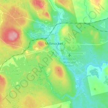
Name: Millinocket topographic map, elevation, terrain.
Location: Millinocket, Penobscot County, Maine, 04462, United States (45.61065 -68.75326 45.68671 -68.62147)
Average elevation: 140 m
Minimum elevation: 100 m
Maximum elevation: 218 m
The town is crossed by State Route 11 and State Route 157. The town of East Millinocket is located 8 miles (13 km) to the east. Millinocket is the closest town to Mount Katahdin, located in Baxter State Park 20 miles (32 km) to the northwest. At an elevation 5,270 feet (1,610 m), its summit is the highest point in Maine and the northern terminus of the Appalachian Trail.
Other topographic maps
Click on a map to view its topography, its elevation and its terrain.
Milford
United States > Maine > Penobscot County
Milford, Penobscot County, Maine, 04461, United States
Average elevation: 40 m
Prentiss Township
United States > Maine > Penobscot County
Prentiss Township, Penobscot County, Maine, United States
Average elevation: 153 m
Lakeville
United States > Maine > Penobscot County
Lakeville, Penobscot County, Maine, United States
Average elevation: 132 m
Lee
United States > Maine > Penobscot County
Lee, Penobscot County, Maine, 04455, United States
Average elevation: 130 m
Hermon
United States > Maine > Penobscot County
Hermon, Penobscot County, Maine, 04401, United States
Average elevation: 53 m
Orono
United States > Maine > Penobscot County
Orono, Penobscot County, Maine, United States
Average elevation: 44 m