
Lynden topographic map
Interactive map
Click on the map to display elevation.
About this map
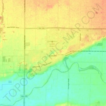
Name: Lynden topographic map, elevation, terrain.
Location: Lynden, Whatcom County, Washington, United States (48.93158 -122.50730 48.96479 -122.40181)
Average elevation: 26 m
Minimum elevation: 7 m
Maximum elevation: 44 m
Other topographic maps
Click on a map to view its topography, its elevation and its terrain.
Point Roberts
United States > Washington > Whatcom County > Point Roberts
Point Roberts, Whatcom County, Washington, 98281, United States
Average elevation: 9 m
Sudden Valley
United States > Washington > Whatcom County
Sudden Valley, Whatcom County, Washington, United States
Average elevation: 239 m
Birch Bay
United States > Washington > Whatcom County
Birch Bay, Whatcom County, Washington, United States
Average elevation: 21 m
Maple Falls
United States > Washington > Whatcom County
Maple Falls, Whatcom County, Washington, United States
Average elevation: 442 m
Ferndale
United States > Washington > Whatcom County
Ferndale, Whatcom County, Washington, United States
Average elevation: 29 m
Sumas
United States > Washington > Whatcom County
Sumas, Whatcom County, Washington, 98295, United States
Average elevation: 15 m
Mount Baker
United States > Washington > Whatcom County
Mount Baker, Whatcom County, Washington, United States
Average elevation: 2,699 m
Bellingham
United States > Washington > Whatcom County
Bellingham, Whatcom County, Washington, United States
Average elevation: 89 m
Blaine
United States > Washington > Whatcom County
Blaine, Whatcom County, Washington, 98231, United States
Average elevation: 23 m
Newhalem
United States > Washington > Whatcom County
Newhalem, Whatcom County, Washington, United States
Average elevation: 492 m