
Catchacoma Lake topographic map
Interactive map
Click on the map to display elevation.
About this map
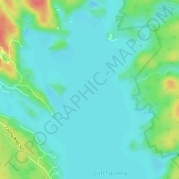
Name: Catchacoma Lake topographic map, elevation, terrain.
Average elevation: 305 m
Minimum elevation: 291 m
Maximum elevation: 349 m
Other topographic maps
Click on a map to view its topography, its elevation and its terrain.
Buckhorn Lake
Canada > Ontario > Trent Lakes > Buckhorn
Buckhorn Lake, Fire Route 26a, Buckhorn, Trent Lakes, Peterborough County, Central Ontario, Ontario, K0L 1J0, Canada
Average elevation: 256 m
Catchacoma Narrows
Canada > Ontario > Trent Lakes
Catchacoma Narrows, Trent Lakes, Peterborough County, Central Ontario, Ontario, Canada
Average elevation: 302 m
Nogies Creek
Canada > Ontario > Trent Lakes
Nogies Creek, Trent Lakes, Peterborough County, Central Ontario, Ontario, Canada
Average elevation: 326 m
Pencil Lake
Canada > Ontario > Trent Lakes
Pencil Lake, Cedarwood Drive, Trent Lakes, Peterborough County, Ontario, Canada
Average elevation: 333 m
Nogies Creek
Canada > Ontario > Trent Lakes
Nogies Creek, Trent Lakes, Peterborough County, Ontario, Canada
Average elevation: 310 m