
Juab County topographic map
Interactive map
Click on the map to display elevation.
About this map
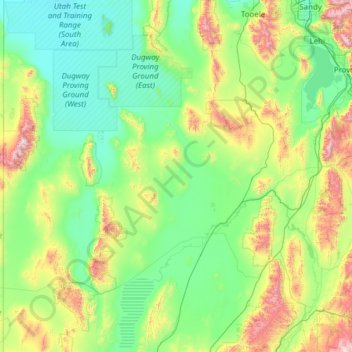
Name: Juab County topographic map, elevation, terrain.
Location: Juab County, Utah, United States (39.31448 -114.04765 40.01166 -111.58479)
Average elevation: 1,647 m
Minimum elevation: 1,284 m
Maximum elevation: 3,620 m
Juab County lies on the west side of Utah. Its west border abuts the east border of the state of Nevada. Its planar areas consist of rugged, arid semi-arable fine-grain soil, with hills and low mountains. Its eastern border is loosely defined by the ridgeline of an arm of the Wasatch Mountains. The terrain generally slopes to the north, with its highest point on Mount Ibapah, a crest of the East Central Great Basin Range in northwest Juab County. The listed elevation of Mt. Ibapah is 12,087' (3684m) ASL. The county has a total area of 3,406 square miles (8,820 km2), of which 3,392 square miles (8,790 km2) is land and 14 square miles (36 km2) (0.4%) is water. The county's shape bears resemblance to the shape of Massachusetts.
Other topographic maps
Click on a map to view its topography, its elevation and its terrain.
Salt Lake City
United States > Utah > Salt Lake County
Salt Lake City, Salt Lake County, Utah, United States
Average elevation: 1,592 m
St. George
United States > Utah > Washington County
St. George, Washington County, Utah, United States
Average elevation: 929 m
Cedar City
United States > Utah > Iron County
Cedar City, Iron County, Utah, United States
Average elevation: 1,975 m
Logan
United States > Utah > Cache County
Logan, Cache County, Utah, United States
Average elevation: 1,498 m
West Jordan
United States > Utah > Salt Lake County
West Jordan, Salt Lake County, Utah, United States
Average elevation: 1,372 m
Layton
United States > Utah > Davis County
Layton, Davis County, Utah, United States
Average elevation: 1,373 m
Bountiful
United States > Utah > Davis County
Bountiful, Davis County, Utah, 84010, United States
Average elevation: 1,477 m
Herriman
United States > Utah > Salt Lake County
Herriman, Salt Lake County, Utah, United States
Average elevation: 1,643 m
Moab
United States > Utah > Grand County
Moab, Grand County, Utah, 84532, United States
Average elevation: 1,357 m
Provo
United States > Utah > Utah County
Provo, Utah County, Utah, United States
Average elevation: 1,728 m
Goshen
United States > Utah > Utah County
Goshen, Utah County, Utah, 84633, United States
Average elevation: 1,393 m
Park City
United States > Utah > Summit County
Park City, Summit County, Utah, United States
Average elevation: 2,290 m
Orem
United States > Utah > Utah County
Orem, Utah County, Utah, United States
Average elevation: 1,458 m
Sandy
United States > Utah > Salt Lake County
Sandy, Salt Lake County, Utah, United States
Average elevation: 1,376 m
Eagle Mountain
United States > Utah > Utah County
Eagle Mountain, Utah County, Utah, 84005, United States
Average elevation: 1,589 m
Kimball Junction
United States > Utah > Summit County > Kimball Junction
Kimball Junction, Summit County, Utah, 84098, United States
Average elevation: 2,004 m
Allen Canyon
United States > Utah > San Juan County
Allen Canyon, San Juan County, Utah, United States
Average elevation: 1,950 m
Zion National Park
United States > Utah > Washington County
Zion National Park, Washington County, Utah, United States
Average elevation: 1,877 m
Campbell
United States > Utah > Davis County > Bountiful
Campbell, Bountiful, Davis County, Utah, 84014, United States
Average elevation: 1,347 m
South Jordan
United States > Utah > Salt Lake County
South Jordan, Salt Lake County, Utah, 84095, United States
Average elevation: 1,407 m
Heber City
United States > Utah > Wasatch County > Heber > Heber City
Heber City, Heber, Wasatch County, Utah, 84032, United States
Average elevation: 1,759 m
Taylorsville
United States > Utah > Salt Lake County
Taylorsville, Salt Lake County, Utah, United States
Average elevation: 1,325 m
Lehi
United States > Utah > Utah County
Lehi, Utah County, Utah, 84043, United States
Average elevation: 1,465 m
North Ogden
United States > Utah > Weber County
North Ogden, Weber County, Utah, 84414, United States
Average elevation: 1,464 m
Trenton
United States > Utah > Cache County
Trenton, Cache County, Utah, 84338, United States
Average elevation: 1,392 m
Lost Acres
United States > Utah > Salt Lake County
Lost Acres, Salt Lake County, Utah, United States
Average elevation: 2,329 m
Garden
United States > Utah > Rich County > Garden City
Garden, Garden City, Rich County, Utah, United States
Average elevation: 2,100 m
Hite Point
United States > Utah > Garfield County
Hite Point, Garfield County, Utah, United States
Average elevation: 1,348 m
Benson
United States > Utah > Cache County
Benson, Cache County, Utah, United States
Average elevation: 1,442 m
Plymouth
United States > Utah > Box Elder County
Plymouth, Box Elder County, Utah, United States
Average elevation: 1,391 m
Riverside
United States > Utah > Box Elder County
Riverside, Box Elder County, Utah, 84334, United States
Average elevation: 1,341 m
South Willard
United States > Utah > Box Elder County
South Willard, Box Elder County, Utah, 84340, United States
Average elevation: 1,417 m
Peter
United States > Utah > Cache County > Petersboro
Peter, Petersboro, Cache County, Utah, United States
Average elevation: 1,445 m
Lewiston
United States > Utah > Cache County
Lewiston, Cache County, Utah, 84320, United States
Average elevation: 1,376 m
Soapstone Mountain
United States > Utah > Wasatch County
Soapstone Mountain, Wasatch County, Utah, United States
Average elevation: 2,720 m
Hyrum
United States > Utah > Cache County
Hyrum, Cache County, Utah, 84319, United States
Average elevation: 1,439 m
Pine Valley
United States > Utah > Washington County
Pine Valley, Washington County, Utah, 84781, United States
Average elevation: 2,092 m
Howell
United States > Utah > Box Elder County
Howell, Box Elder County, Utah, 84316, United States
Average elevation: 1,460 m
Clarkston
United States > Utah > Cache County
Clarkston, Cache County, Utah, 84305, United States
Average elevation: 1,498 m
Echo
United States > Utah > Summit County
Echo, Summit County, Utah, 84024, United States
Average elevation: 1,792 m
Monroe
United States > Utah > Sevier County
Monroe, Sevier County, Utah, 84754, United States
Average elevation: 1,678 m
Pleasant View
United States > Utah > Weber County
Pleasant View, Weber County, Utah, United States
Average elevation: 1,447 m
South Ogden
United States > Utah > Weber County
South Ogden, Weber County, Utah, 84405, United States
Average elevation: 1,403 m
The Three Peaks
United States > Utah > Iron County
The Three Peaks, Iron County, Utah, United States
Average elevation: 1,789 m
Desert Mountain
United States > Utah > Juab County
Desert Mountain, Juab County, Utah, United States
Average elevation: 1,673 m
Cottonwood Heights
United States > Utah > Salt Lake County
Cottonwood Heights, Salt Lake County, Utah, United States
Average elevation: 1,470 m
Dammeron Valley
United States > Utah > Washington County
Dammeron Valley, Washington County, Utah, 84783, United States
Average elevation: 1,444 m
Lake Powell
United States > Utah > San Juan County
Lake Powell, San Juan County, Utah, United States
Average elevation: 1,555 m
Linwood Bay
United States > Utah > Daggett County
Linwood Bay, Daggett County, Utah, United States
Average elevation: 1,852 m
White City
United States > Utah > Salt Lake County
White City, Salt Lake County, Utah, United States
Average elevation: 1,403 m