
Pai topographic map
Interactive map
Click on the map to display elevation.
About this map
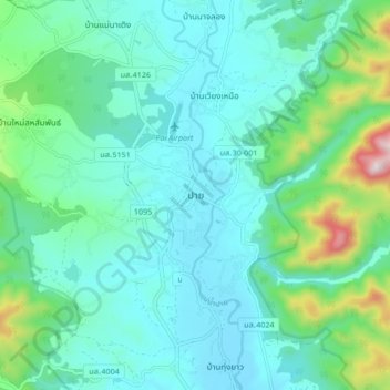
Name: Pai topographic map, elevation, terrain.
Location: Pai, Mae Hong Son Province, 58130, Thailand (19.31811 98.40058 19.39811 98.48058)
Average elevation: 605 m
Minimum elevation: 487 m
Maximum elevation: 1,109 m
Other topographic maps
Click on a map to view its topography, its elevation and its terrain.
Ban Huai Pu
Thailand > Mae Hong Son Province > Ban Rai
Ban Huai Pu, Ban Rai, Mae Yuam, Mae Sariang, Mae Hong Son Province, 58110, Thailand
Average elevation: 249 m
Ban Na Kao
Thailand > Mae Hong Son Province > Ban Na Kao
Ban Na Kao, Mae Hong Son Province, 58110, Thailand
Average elevation: 269 m
Mae Hong Son Province
Thailand > Mae Hong Son Province
Mae Hong Son Province, Thailand
Average elevation: 604 m