
Pike Bay topographic map
Interactive map
Click on the map to display elevation.
About this map
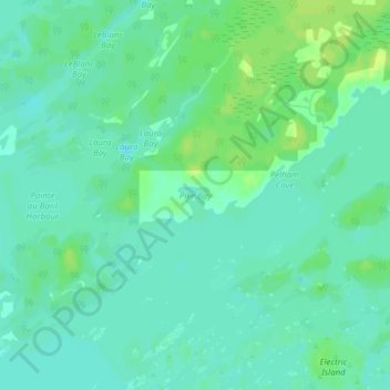
Name: Pike Bay topographic map, elevation, terrain.
Average elevation: 178 m
Minimum elevation: 172 m
Maximum elevation: 186 m
Other topographic maps
Click on a map to view its topography, its elevation and its terrain.
Keats Island
Canada > Ontario > The Archipelago Township
Keats Island, The Archipelago Township, Parry Sound District, Central Ontario, Ontario, Canada
Average elevation: 194 m
Bayfield Inlet
Canada > Ontario > The Archipelago Township
Bayfield Inlet, The Archipelago Township, Parry Sound District, Central Ontario, Ontario, Canada
Average elevation: 181 m
The Archipelago Township
Canada > Ontario > The Archipelago Township
The Archipelago Township, Parry Sound District, Central Ontario, Ontario, P0G 1K0, Canada
Average elevation: 204 m
Naiscoot Lake
Canada > Ontario > The Archipelago Township
Naiscoot Lake, The Archipelago Township, Parry Sound District, Central Ontario, Ontario, Canada
Average elevation: 211 m
Lumsden Island
Canada > Ontario > The Archipelago Township
Lumsden Island, The Archipelago Township, Parry Sound District, Central Ontario, Ontario, Canada
Average elevation: 199 m
Hurontario Island
Canada > Ontario > The Archipelago Township
Hurontario Island, The Archipelago Township, Parry Sound District, Central Ontario, Ontario, Canada
Average elevation: 197 m
Brewery Lake
Canada > Ontario > The Archipelago Township
Brewery Lake, Dumont Road, The Archipelago Township, Parry Sound District, Central Ontario, Ontario, Canada
Average elevation: 217 m