
Kigali topographic map
Interactive map
Click on the map to display elevation.
About this map
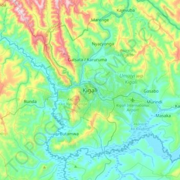
Name: Kigali topographic map, elevation, terrain.
Location: Kigali, Nyarugenge District, Kigali City, Rwanda (-2.11085 29.90151 -1.79085 30.22151)
Average elevation: 1,530 m
Minimum elevation: 1,334 m
Maximum elevation: 2,180 m
Kigali is located in the centre of Rwanda, at 1°57′S 30°4′E. Like the rest of Rwanda it uses Central Africa Time, and is two hours ahead of Coordinated Universal Time (UTC+02:00) throughout the year. The city is coterminous with the province of Kigali, one of the five provinces of Rwanda introduced in 2006 as part of a restructuring of local government in the country. The city has boundaries with the Northern, Eastern and Southern provinces. It is divided into three administrative districts—Nyarugenge in the south west, Kicukiro in the south east, and Gasabo, which occupies the northern half of the city's territory. The built-up urban area covers about 70 per cent of the municipal boundaries. Kigali lies in a region of rolling hills, with a series of valleys and ridges joined by steep slopes. It is situated between Mount Kigali and Mount Jali, both of which have elevations of more than 1,800 m (5,906 ft) above sea level, while the lowest areas of the city have an altitude of 1,300 m (4,265 ft). Geologically, Kigali is in a granitic and metasedimentary region, with lateritic soils on the hills and alluvial soils in the valleys.