
Mildred topographic map
Interactive map
Click on the map to display elevation.
About this map
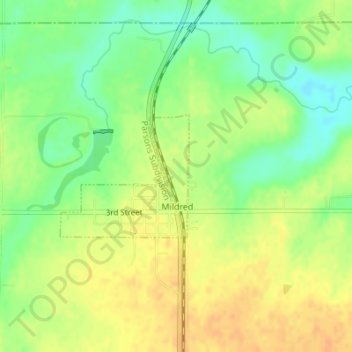
Name: Mildred topographic map, elevation, terrain.
Location: Mildred, Allen County, Kansas, United States (38.02125 -95.18252 38.03070 -95.16996)
Average elevation: 321 m
Minimum elevation: 302 m
Maximum elevation: 335 m
Other topographic maps
Click on a map to view its topography, its elevation and its terrain.
Bayard
United States > Kansas > Allen County
Bayard, Allen County, Kansas, United States
Average elevation: 321 m
Moran
United States > Kansas > Allen County
Moran, Allen County, Kansas, United States
Average elevation: 334 m
Mildred Lake
United States > Kansas > Allen County > Mildred
Mildred Lake, Mildred, Allen County, Kansas, United States
Average elevation: 320 m