
Pillar Lake topographic map
Interactive map
Click on the map to display elevation.
About this map
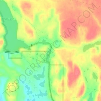
Name: Pillar Lake topographic map, elevation, terrain.
Location: Pillar Lake, Grant County, Washington, United States (46.95265 -119.22512 46.95911 -119.22087)
Average elevation: 321 m
Minimum elevation: 284 m
Maximum elevation: 350 m
Other topographic maps
Click on a map to view its topography, its elevation and its terrain.
Moses Lake
United States > Washington > Grant County
Moses Lake, Grant County, Washington, 98837, United States
Average elevation: 350 m
Smyrna
United States > Washington > Grant County
Smyrna, Grant County, Washington, United States
Average elevation: 279 m
Jackass Mountain
United States > Washington > Grant County
Jackass Mountain, Grant County, Washington, United States
Average elevation: 328 m
Osborn Bay
United States > Washington > Grant County
Osborn Bay, Grant County, Washington, 99123, United States
Average elevation: 528 m