
Goodwood topographic map
Interactive map
Click on the map to display elevation.
About this map
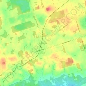
Name: Goodwood topographic map, elevation, terrain.
Average elevation: 338 m
Minimum elevation: 300 m
Maximum elevation: 372 m
Other topographic maps
Click on a map to view its topography, its elevation and its terrain.
Sandford
Canada > Ontario > Durham Region > Uxbridge
Sandford, Uxbridge, Durham Region, Golden Horseshoe, Ontario, L0C 1E0, Canada
Average elevation: 285 m
Zephyr
Canada > Ontario > Durham Region > Uxbridge
Zephyr, Uxbridge, Durham Region, Golden Horseshoe, Ontario, L0E 1T0, Canada
Average elevation: 253 m