
Châteauguay topographic map
Interactive map
Click on the map to display elevation.
About this map
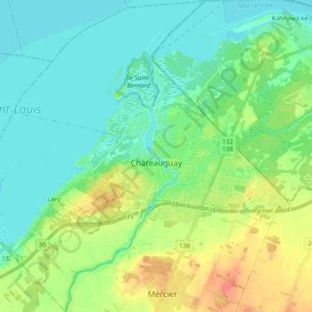
Name: Châteauguay topographic map, elevation, terrain.
Location: Châteauguay, Roussillon, Montérégie, Quebec, Canada (45.30359 -73.82651 45.42178 -73.67530)
Average elevation: 32 m
Minimum elevation: 18 m
Maximum elevation: 63 m
Other topographic maps
Click on a map to view its topography, its elevation and its terrain.
Mercier
Canada > Quebec > Roussillon
Mercier, Roussillon, Montérégie, Quebec, Canada
Average elevation: 43 m
Saint-Philippe
Canada > Quebec > Roussillon
Saint-Philippe, Roussillon, Montérégie, Quebec, J0L 2K0, Canada
Average elevation: 36 m
Candiac
Canada > Quebec > Roussillon
Candiac, Roussillon, Montérégie, Quebec, Canada
Average elevation: 26 m
Saint-Constant
Canada > Quebec > Roussillon
Saint-Constant, Roussillon, Montérégie, Quebec, Canada
Average elevation: 37 m
Saint-Mathieu
Canada > Quebec > Roussillon
Saint-Mathieu, Roussillon, Montérégie, Quebec, J0L 2H0, Canada
Average elevation: 42 m