
Mount Arrowsmith topographic map
Interactive map
Click on the map to display elevation.
About this map
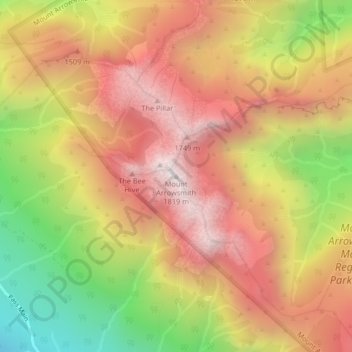
Name: Mount Arrowsmith topographic map, elevation, terrain.
Average elevation: 1,281 m
Minimum elevation: 588 m
Maximum elevation: 1,800 m
Other topographic maps
Click on a map to view its topography, its elevation and its terrain.
Fishtail Lake
Canada > British Columbia > Regional District of Nanaimo > Area C (Arrowsmith-Benson)
Fishtail Lake, Area C (Arrowsmith-Benson), Regional District of Nanaimo, British Columbia, Canada
Average elevation: 1,155 m
Extension
Canada > British Columbia > Regional District of Nanaimo > Area C (Arrowsmith-Benson)
Extension, Area C (Arrowsmith-Benson), Regional District of Nanaimo, British Columbia, V9R 4A1, Canada
Average elevation: 175 m