
Salem West topographic map
Interactive map
Click on the map to display elevation.
About this map
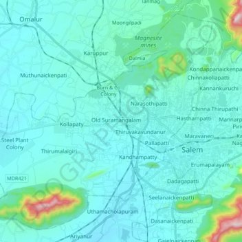
Name: Salem West topographic map, elevation, terrain.
Location: Salem West, Salem District, Tamil Nadu, India (11.60091 78.00589 11.74677 78.17267)
Average elevation: 324 m
Minimum elevation: 244 m
Maximum elevation: 1,008 m
Other topographic maps
Click on a map to view its topography, its elevation and its terrain.
Burn & Co Colony
India > Tamil Nadu > Salem West
Burn & Co Colony, Salem West, Salem District, Tamil Nadu, 636302, India
Average elevation: 304 m