
County of Vermilion River topographic map
Interactive map
Click on the map to display elevation.
About this map
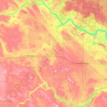
Name: County of Vermilion River topographic map, elevation, terrain.
Location: County of Vermilion River, Alberta, Canada (52.85521 -111.03873 53.88950 -110.00537)
Average elevation: 638 m
Minimum elevation: 492 m
Maximum elevation: 783 m
Other topographic maps
Click on a map to view its topography, its elevation and its terrain.
Village of Marwayne
Canada > Alberta > County of Vermilion River
Village of Marwayne, County of Vermilion River, Alberta, T0B 2X0, Canada
Average elevation: 603 m
Blackfoot
Canada > Alberta > County of Vermilion River
Blackfoot, County of Vermilion River, Alberta, T0B 0L0, Canada
Average elevation: 677 m