
Val-des-Sources topographic map
Interactive map
Click on the map to display elevation.
About this map
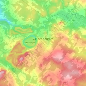
Name: Val-des-Sources topographic map, elevation, terrain.
Location: Val-des-Sources, Les Sources, Estrie, Quebec, Canada (45.73878 -72.01236 45.80482 -71.87375)
Average elevation: 231 m
Minimum elevation: 114 m
Maximum elevation: 359 m
Other topographic maps
Click on a map to view its topography, its elevation and its terrain.
Saint-Camille
Canada > Quebec > Les Sources > Saint-Camille
Saint-Camille, Les Sources, Estrie, Quebec, Canada
Average elevation: 305 m
Parc régional du Mont-Ham
Canada > Quebec > Les Sources > Ham-Sud
Parc régional du Mont-Ham, Ham-Sud, Les Sources, Estrie, Quebec, Canada
Average elevation: 354 m