
Maasin topographic map
Interactive map
Click on the map to display elevation.
About this map
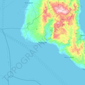
Name: Maasin topographic map, elevation, terrain.
Location: Maasin, Southern Leyte, Eastern Visayas, Philippines (9.97253 124.67846 10.29253 124.99846)
Average elevation: 90 m
Minimum elevation: 0 m
Maximum elevation: 687 m
Other topographic maps
Click on a map to view its topography, its elevation and its terrain.
Panaon Island
Philippines > Southern Leyte > Maasin
Panaon Island, Maasin, Southern Leyte, Eastern Visayas, 6612, Philippines
Average elevation: 61 m