
Tamworth topographic map
Interactive map
Click on the map to display elevation.
About this map
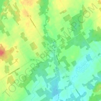
Name: Tamworth topographic map, elevation, terrain.
Average elevation: 166 m
Minimum elevation: 142 m
Maximum elevation: 200 m
Other topographic maps
Click on a map to view its topography, its elevation and its terrain.
Puzzle Lake Provincial Park
Canada > Ontario > Lennox and Addington County > Stone Mills
Puzzle Lake Provincial Park, Stone Mills, Lennox and Addington County, Eastern Ontario, Ontario, Canada
Average elevation: 196 m
Newburgh
Canada > Ontario > Lennox and Addington County > Stone Mills
Newburgh, Stone Mills, Greater Napanee, Lennox and Addington County, Eastern Ontario, Ontario, K0K 2S0, Canada
Average elevation: 129 m
Colebrook
Canada > Ontario > Lennox and Addington County > Stone Mills
Colebrook, Stone Mills, Lennox and Addington County, Eastern Ontario, Ontario, K0K 3N0, Canada
Average elevation: 153 m
Erinsville
Canada > Ontario > Lennox and Addington County > Stone Mills
Erinsville, Stone Mills, Lennox and Addington County, Eastern Ontario, Ontario, K0K 2A0, Canada
Average elevation: 174 m
Yarker
Canada > Ontario > Lennox and Addington County > Stone Mills
Yarker, Stone Mills, Lennox and Addington County, Eastern Ontario, Ontario, K0K 3N0, Canada
Average elevation: 152 m
Moscow
Canada > Ontario > Lennox and Addington County > Stone Mills
Moscow, Stone Mills, Lennox and Addington County, Eastern Ontario, Ontario, Canada
Average elevation: 146 m