
Neyrac-les-Bains topographic map
Interactive map
Click on the map to display elevation.
About this map
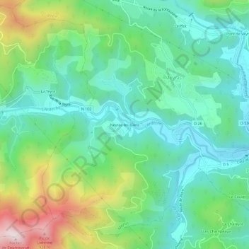
Name: Neyrac-les-Bains topographic map, elevation, terrain.
Average elevation: 493 m
Minimum elevation: 303 m
Maximum elevation: 958 m
Other topographic maps
Click on a map to view its topography, its elevation and its terrain.
Le Plot
France > Auvergne-Rhône-Alpes > Ardèche > Meyras
Le Plot, Meyras, Largentière, Ardèche, Auvergne-Rhône-Alpes, France métropolitaine, 07380, France
Average elevation: 488 m
Le Plot
France > Auvergne-Rhône-Alpes > Ardèche > Meyras
Le Plot, Meyras, Largentière, Ardèche, Auvergne-Rhône-Alpes, France métropolitaine, 07380, France
Average elevation: 480 m