
Sderot topographic map
Interactive map
Click on the map to display elevation.
About this map
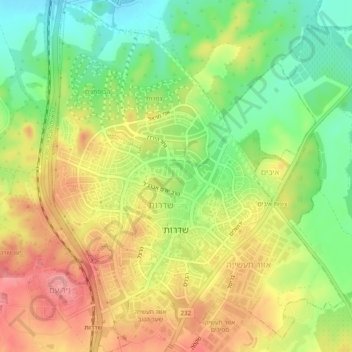
Name: Sderot topographic map, elevation, terrain.
Location: Sderot, Ashkelon Subdistrict, South District, Israel (31.51198 34.57962 31.55377 34.62025)
Average elevation: 84 m
Minimum elevation: 38 m
Maximum elevation: 129 m
Other topographic maps
Click on a map to view its topography, its elevation and its terrain.
Arad
Arad, Beersheba Subdistrict, South District, Israel
Average elevation: 579 m
Ramat Negev Regional Council
Ramat Negev Regional Council, Beersheba Subdistrict, South District, 8499300, Israel
Average elevation: 415 m
Lehavim
Lehavim, Beersheba Subdistrict, South District, Israel
Average elevation: 316 m
Tamar Regional Council
Tamar Regional Council, Beersheba Subdistrict, South District, Israel
Average elevation: 272 m
Ashdod
Ashdod, Ashkelon Subdistrict, South District, 7750502, Israel
Average elevation: 31 m
Ashkelon
Israel > South District > Ashkelon
Ashkelon, Ashkelon Subdistrict, South District, 7875809, Israel
Average elevation: 38 m
Eilat
Eilat, Beersheba Subdistrict, South District, 8804625, Israel
Average elevation: 405 m
The Water Gate
Israel > South District > Tamar Regional Council
The Water Gate, Snake Path, Tamar Regional Council, Beersheba Subdistrict, South District, no, Israel
Average elevation: -139 m
Ashkelon
Ashkelon, Ashkelon Subdistrict, South District, Israel
Average elevation: 31 m
Be'er Sheva
Israel > South District > Be'er Sheva
Be'er Sheva, South District, Israel
Average elevation: 282 m
Ashdod
Israel > South District > Ashdod
Ashdod, Ashkelon Subdistrict, South District, Israel
Average elevation: 17 m