
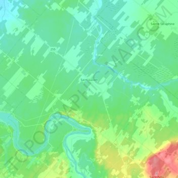
Saint-Lucien topographic map
Interactive map
Click on the map to display elevation.
About this map
Name: Saint-Lucien topographic map, elevation, terrain.
Average elevation: 113 m
Minimum elevation: 86 m
Maximum elevation: 206 m
Other topographic maps
Click on a map to view its topography, its elevation and its terrain.
Saint-Germain-de-Grantham
Saint-Germain-de-Grantham, Drummond, Centre-du-Québec, Quebec, J0C 1K0, Canada
Average elevation: 84 m
Drummondville
Drummondville, Drummond, Centre-du-Québec, Quebec, Canada
Average elevation: 86 m