
Gretna topographic map
Interactive map
Click on the map to display elevation.
About this map
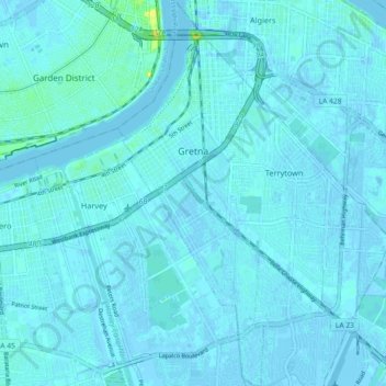
Name: Gretna topographic map, elevation, terrain.
Location: Gretna, Jefferson Parish, Louisiana, 70053, United States (29.86676 -90.07167 29.94551 -90.03729)
Average elevation: 2 m
Minimum elevation: -5 m
Maximum elevation: 19 m
Gretna is located at 29°54′59″N 90°3′15″W / 29.91639°N 90.05417°W / 29.91639; -90.05417 (29.916459, -90.054260) and has an elevation of 0 feet (0 m) behind the levee along the Mississippi River.
Other topographic maps
Click on a map to view its topography, its elevation and its terrain.
Kenner
United States > Louisiana > Jefferson Parish
Kenner, Jefferson Parish, Louisiana, United States
Average elevation: 1 m
Elmwood
United States > Louisiana > Jefferson Parish
Elmwood, Jefferson Parish, Louisiana, United States
Average elevation: 3 m