
Paravur topographic map
Interactive map
Click on the map to display elevation.
About this map
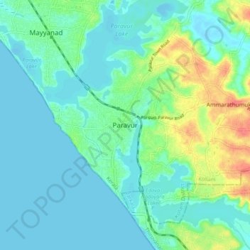
Name: Paravur topographic map, elevation, terrain.
Location: Paravur, Kollam, Kerala, 691301, India (8.76989 76.63153 8.84989 76.71153)
Average elevation: 14 m
Minimum elevation: -5 m
Maximum elevation: 60 m
Paravur is located at 8.78 N 76 E. It has an average elevation of 10 metres (32 feet). Paravur, 21 kilometers from the Kollam, is a narrow skirt of land stretching in between the backwaters and the sea. There is an elevation of 6 metres above sea level, extending to 16 metres on the inland.