
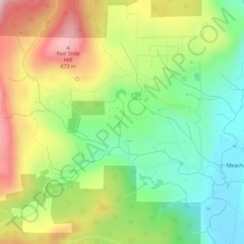
Grebe Creek topographic map
Interactive map
Click on the map to display elevation.
About this map
Name: Grebe Creek topographic map, elevation, terrain.
Average elevation: 262 m
Minimum elevation: 95 m
Maximum elevation: 495 m
Other topographic maps
Click on a map to view its topography, its elevation and its terrain.
Parkdale
United States of America > Oregon > Parkdale
Parkdale, Hood River County, Oregon, 97041, United States of America
Average elevation: 540 m
Cultus Lake
United States of America > Oregon
Cultus Lake, Metolius-Windigo Trail, Deschutes County, Oregon, United States of America
Average elevation: 1,511 m
Firwood
United States of America > Oregon > Firwood
Firwood, Clackamas County, Oregon, United States of America
Average elevation: 379 m
Dutch Point
United States of America > Oregon
Dutch Point, Brown Road, Wallowa County, Oregon, United States of America
Average elevation: 991 m
Serviceberry Creek
United States of America > Oregon
Serviceberry Creek, Douglas County, Oregon, United States of America
Average elevation: 1,018 m
Grizzly
United States of America > Oregon > Grizzly
Grizzly, Jefferson County, Oregon, United States of America
Average elevation: 1,147 m
Gibbon
United States of America > Oregon > Gibbon
Gibbon, Umatilla County, Oregon, United States of America
Average elevation: 683 m
The Villages at Mount Hood
United States of America > Oregon > The Villages at Mount Hood
The Villages at Mount Hood, Clackamas County, Oregon, United States of America
Average elevation: 797 m
Deadwood
United States of America > Oregon > Deadwood
Deadwood, Lane County, Oregon, United States of America
Average elevation: 212 m
Astoria
United States of America > Oregon > Astoria
Astoria, Clatsop County, Oregon, 97103, United States of America
Average elevation: 15 m
Middle Fork Beaver Creek
United States of America > Oregon > Portland
Middle Fork Beaver Creek, Portland, Multnomah County, Oregon, 97009, United States of America
Average elevation: 178 m
Cascade Range
United States of America > Oregon
Cascade Range, Lane County, Oregon, United States of America
Average elevation: 1,698 m
God's Thumb
United States of America > Oregon
God's Thumb, Lincoln County, Oregon, 97364, United States of America
Average elevation: 29 m
Cathedral Park
United States of America > Oregon > Portland
Cathedral Park, Portland, Multnomah County, Oregon, United States of America
Average elevation: 46 m
Irrigon
United States of America > Oregon > Irrigon
Irrigon, Morrow County, Oregon, United States of America
Average elevation: 91 m