
Knysna Local Municipality topographic map
Interactive map
Click on the map to display elevation.
About this map
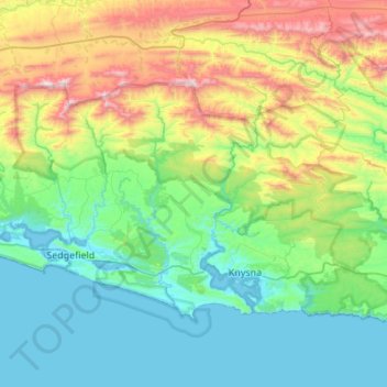
Name: Knysna Local Municipality topographic map, elevation, terrain.
Average elevation: 353 m
Minimum elevation: -4 m
Maximum elevation: 1,437 m
Other topographic maps
Click on a map to view its topography, its elevation and its terrain.
De Vlugt
South Africa > Western Cape > Garden Route District Municipality > George Local Municipality
De Vlugt, George Local Municipality, Garden Route District Municipality, Western Cape, South Africa
Average elevation: 457 m
Stormberg
South Africa > Western Cape > Garden Route District Municipality > George Local Municipality
Stormberg, George Local Municipality, Garden Route District Municipality, Western Cape, South Africa
Average elevation: 962 m