
Gambela Region topographic map
Interactive map
Click on the map to display elevation.
About this map
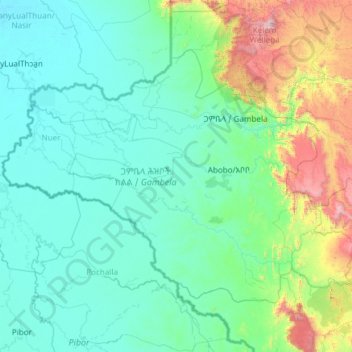
Name: Gambela Region topographic map, elevation, terrain.
Location: Gambela Region, Ethiopia (7.00785 32.99758 8.61114 35.36670)
Average elevation: 689 m
Minimum elevation: 397 m
Maximum elevation: 3,164 m
Anywaa zone is by far the largest of the zones of Gambela Region and also includes the capital, Gambela. The terrain is mostly flat at elevations between 400 – 550 meters above sea level but with the eastern fringes of Anywaa zone and in particular the easternmost zone, Majang, being partly in the highlands and going up to an elevation of ~2000 meters near the eastern border.