
Jijiga topographic map
Interactive map
Click on the map to display elevation.
About this map
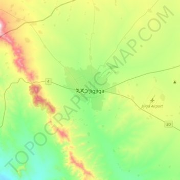
Name: Jijiga topographic map, elevation, terrain.
Location: Jijiga, Somali Region, Ethiopia (9.19085 42.64038 9.51085 42.96038)
Average elevation: 1,732 m
Minimum elevation: 1,393 m
Maximum elevation: 2,474 m
Jijiga (Amharic: ጂጂጋ; Somali: Jigjiga) is a city in the Somali Region of Ethiopia. It became the capital of the Somali Regional State in 1995 after it was moved from Godey. Located in the Fafan Zone with 60 km (37 mi) west of the border with Somaliland, the city has an elevation of 1,934 metres above sea level.