
Hawassa topographic map
Interactive map
Click on the map to display elevation.
About this map
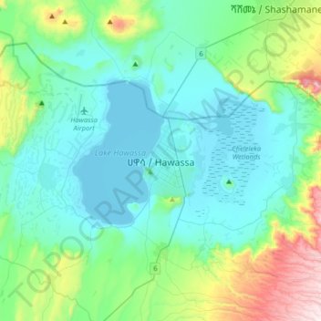
Name: Hawassa topographic map, elevation, terrain.
Location: Hawassa, Sidama, 1923, Ethiopia (6.88810 38.31861 7.20810 38.63861)
Average elevation: 1,862 m
Minimum elevation: 1,682 m
Maximum elevation: 2,632 m
Awasa (Amharic: አዋሳ ʾäwasa, also spelled Awassa or Hawassa) is a city in Ethiopia, on the shores of Lake Awasa in the Great Rift Valley. It is 273 km (170 mi) south of Addis Ababa via Bishoftu, 130 km (81 mi) east of Sodo, and 75 km (47 mi) north of Dilla. The town serves as the capital of the Sidama Region and the Southern Nations, Nationalities, and Peoples' Region. It lies on the Trans-African Highway 4 Cairo-Cape Town and has a latitude and longitude of 7°3′N 38°28′E / 7.050°N 38.467°E / 7.050; 38.467Coordinates: 7°3′N 38°28′E / 7.050°N 38.467°E / 7.050; 38.467 and an elevation of 1,708 meters (5,604 ft) above sea level. Its name comes from a Sidamic word meaning "wide body of water".