
1145 topographic map
Interactive map
Click on the map to display elevation.
About this map
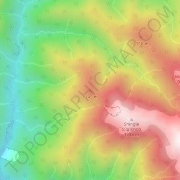
Name: 1145 topographic map, elevation, terrain.
Location: 1145, Carterton District, Wellington, New Zealand (-40.83578 175.39197 -40.83568 175.39207)
Average elevation: 889 m
Minimum elevation: 440 m
Maximum elevation: 1,366 m
Other topographic maps
Click on a map to view its topography, its elevation and its terrain.
Upper Hutt
New Zealand > Wellington > Upper Hutt City
Upper Hutt, Upper Hutt City, Wellington, 5218, New Zealand
Average elevation: 271 m
Blake
New Zealand > Wellington > Masterton District
Blake, Masterton District, Wellington, New Zealand
Average elevation: 568 m
Wellington
New Zealand > Wellington > Wellington City
Wellington, Wellington City, Wellington, 6011, New Zealand
Average elevation: 85 m
McKerrow
New Zealand > Wellington > Lower Hutt City
McKerrow, Lower Hutt City, Wellington, New Zealand
Average elevation: 441 m
Lower Hutt
New Zealand > Wellington > Lower Hutt City > Lower Hutt
Lower Hutt, Lower Hutt City, Wellington, 5010, New Zealand
Average elevation: 173 m
Mt Albert
New Zealand > Wellington > Wellington
Mt Albert, Wellington, Wellington City, Wellington, 6023, New Zealand
Average elevation: 45 m