
Kayamkulam topographic map
Interactive map
Click on the map to display elevation.
About this map
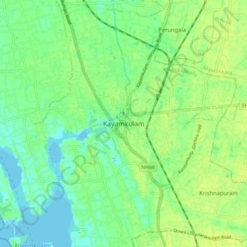
Name: Kayamkulam topographic map, elevation, terrain.
Location: Kayamkulam, Karthikappally, Alappuzha, Kerala, 690502, India (9.13219 76.46087 9.21219 76.54087)
Average elevation: 8 m
Minimum elevation: -1 m
Maximum elevation: 15 m
Other topographic maps
Click on a map to view its topography, its elevation and its terrain.
Karthikappally
India > Kerala > Karthikappally
Karthikappally, Alappuzha, Kerala, India
Average elevation: 4 m