
Caza of Minieh Dahniyeh topographic map
Interactive map
Click on the map to display elevation.
About this map
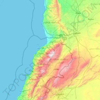
Name: Caza of Minieh Dahniyeh topographic map, elevation, terrain.
Average elevation: 539 m
Minimum elevation: 0 m
Maximum elevation: 3,066 m
Other topographic maps
Click on a map to view its topography, its elevation and its terrain.
Mount Lebanon
Mount Lebanon, Miniyeh-Danniyeh District, North Governorate, Lebanon
Average elevation: 2,819 m
Taran
Lebanon > North Governorate > Taran
Taran, Miniyeh-Danniyeh District, North Governorate, Lebanon
Average elevation: 772 m
Beit Zoud
Beit Zoud, Miniyeh-Danniyeh District, North Governorate, Lebanon
Average elevation: 577 m