
Port-au-Prince topographic map
Interactive map
Click on the map to display elevation.
About this map
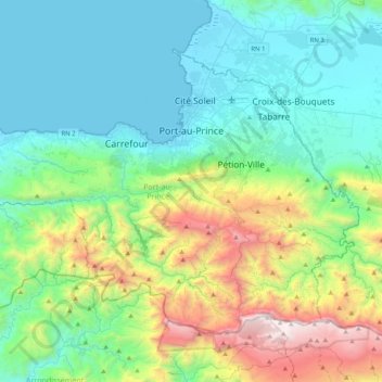
Name: Port-au-Prince topographic map, elevation, terrain.
Location: Port-au-Prince, West, Haiti (18.33990 -72.56977 18.63073 -72.15893)
Average elevation: 532 m
Minimum elevation: 0 m
Maximum elevation: 2,255 m
By then, the colonial administration was convinced that a capital needed to be chosen, in order to better control the French portion of Hispaniola (Saint-Domingue). For a time, Petit-Goâve and Léogâne vied for this honor, but both were eventually ruled out for various reasons. Neither was centrally located. Petit-Goâve's climate caused it to be too malarial, and Léogane's topography made it difficult to defend. Thus, in 1749, a new city was built, Port-au-Prince.
Other topographic maps
Click on a map to view its topography, its elevation and its terrain.
Vandreuil
Haiti > West > Commune Croix-des-Bouquets
Vandreuil, Commune Croix-des-Bouquets, Arrondissement de Croix-des-Bouquets, West, Haiti
Average elevation: 51 m
Arcahaie
Haiti > West > Commune Arcahaie
Arcahaie, Commune Arcahaie, Arrondissement de l’Arcahaie, West, Haiti
Average elevation: 25 m
Vally
Haiti > West > Commune Petit-Goâve > Vally
Vally, Commune Petit-Goâve, Arrondissement de Léogâne, West, CHARLEMAGNE, Haiti
Average elevation: 761 m
Port-au-Prince
Haiti > West > Port-au-Prince
Port-au-Prince, West, BP98, Haiti
Average elevation: 376 m
Gonâve Island
Gonâve Island, Arrondissement de La Gonâve, West, 6510, Haiti
Average elevation: 54 m