
Marlbank topographic map
Interactive map
Click on the map to display elevation.
About this map
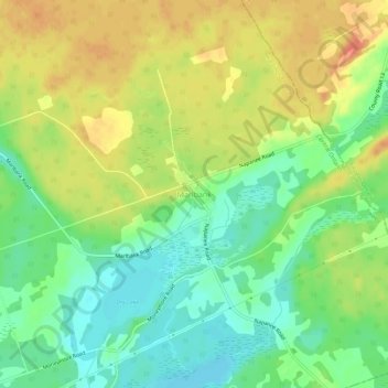
Name: Marlbank topographic map, elevation, terrain.
Average elevation: 176 m
Minimum elevation: 154 m
Maximum elevation: 199 m
Other topographic maps
Click on a map to view its topography, its elevation and its terrain.
Queensborough
Canada > Ontario > Hastings County > Tweed
Queensborough, Tweed, Hastings County, Central Ontario, Ontario, Canada
Average elevation: 207 m
Thomasburg
Canada > Ontario > Hastings County > Tweed
Thomasburg, Tweed, Hastings County, Central Ontario, Ontario, K0K 3H0, Canada
Average elevation: 160 m