
Village of Malone topographic map
Interactive map
Click on the map to display elevation.
About this map
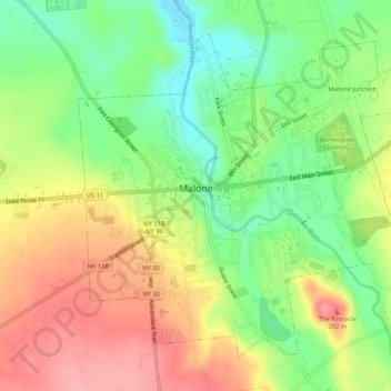
Name: Village of Malone topographic map, elevation, terrain.
Average elevation: 234 m
Minimum elevation: 181 m
Maximum elevation: 291 m
Other topographic maps
Click on a map to view its topography, its elevation and its terrain.
Town of Bangor
United States > New York > Franklin County
Town of Bangor, Franklin County, New York, 12966, United States
Average elevation: 209 m
Town of Chateaugay
United States > New York > Franklin County
Town of Chateaugay, Franklin County, New York, 12920, United States
Average elevation: 280 m
Saginaw Bay
United States > New York > Franklin County > Town of Santa Clara
Saginaw Bay, Town of Santa Clara, Franklin County, New York, United States
Average elevation: 504 m
Akwesasne
United States > New York > Franklin County > Town of Bombay
Akwesasne, Town of Bombay, Franklin County, New York, United States
Average elevation: 57 m
Lake Clear
United States > New York > Franklin County > Town of Harrietstown
Lake Clear, Town of Harrietstown, Franklin County, New York, 12945, United States
Average elevation: 498 m