
Ano Vrontou topographic map
Interactive map
Click on the map to display elevation.
About this map
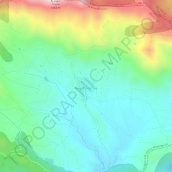
Name: Ano Vrontou topographic map, elevation, terrain.
Average elevation: 1,161 m
Minimum elevation: 972 m
Maximum elevation: 1,624 m
Ano Vrontou (Greek: Άνω Βροντού; Bulgarian: Горно Броди, Gorno Brodi) is a remote mountain village and a former community in the northern Serres regional unit, Greece. Since the 2011 local government reform it is part of the municipality Serres, of which it is a municipal unit. Each year on August astrophotography hobbyists gather there due to the clear view of the night sky, a result of the villages high elevation. The municipal unit has an area of 47.306 km2. In 2011 its population was 199. Ano Vrontou is situated in the northeastern part of the Vrontous mountains, at about 1060 m elevation. It borders on the Drama regional unit to the north and east. Ano Vrontou is 6 km northwest of Kato Vrontou, 12 km east of Achladochori, 13 km northeast of Oreini, 16 km southwest of Kato Nevrokopi and 26 km northeast of Serres.