
Kingston Mills topographic map
Interactive map
Click on the map to display elevation.
About this map
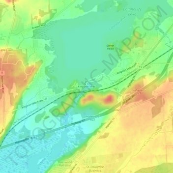
Name: Kingston Mills topographic map, elevation, terrain.
Average elevation: 94 m
Minimum elevation: 70 m
Maximum elevation: 124 m
Other topographic maps
Click on a map to view its topography, its elevation and its terrain.
Manitoba Maple
Canada > Ontario > Kingston > Kingston
Manitoba Maple, Stuart Street, University District, Kingston, Eastern Ontario, Ontario, K7L 2N7, Canada
Average elevation: 84 m