
Combarbalá topographic map
Interactive map
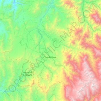
Click on the map to display elevation.
About this map
Name: Combarbalá topographic map, elevation, terrain.
Average elevation: 1,444 m
Minimum elevation: 223 m
Maximum elevation: 4,111 m
Combarbalá is the capital city of the commune of Combarbala. It is located in the Limarí Province, Region of Coquimbo, at an elevation of 900 m (2,952 ft). It is known for the tourist astronomic observatory Cruz del Sur; the petroglyphs of Rincon las Chilcas; its typical handcraft made of the unique combarbalita stone; the classical basketball match at the end February; the Virgen de la Piedra catholic-pagan festivity, among other tourist attractions.