
Muskogee County topographic map
Interactive map
Click on the map to display elevation.
About this map
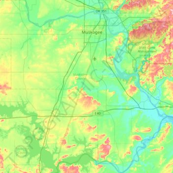
Name: Muskogee County topographic map, elevation, terrain.
Location: Muskogee County, Oklahoma, United States of America (35.26210 -95.76765 35.85766 -95.05057)
Average elevation: 190 m
Minimum elevation: 141 m
Maximum elevation: 328 m
Other topographic maps
Click on a map to view its topography, its elevation and its terrain.
Yukon
United States of America > Oklahoma > Yukon
Yukon, Oklahoma, United States of America
Average elevation: 399 m
Alabaster Caverns State Park
United States of America > Oklahoma
Alabaster Caverns State Park, Woodward County, Oklahoma, United States of America
Average elevation: 518 m
Keetonville
United States of America > Oklahoma > Keetonville
Keetonville, Rogers County, Oklahoma, United States of America
Average elevation: 208 m
Fallis
United States of America > Oklahoma > Fallis
Fallis, Oklahoma, United States of America
Average elevation: 284 m