
Cormorant Island topographic map
Interactive map
Click on the map to display elevation.
About this map
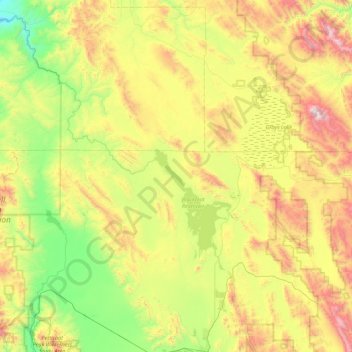
Name: Cormorant Island topographic map, elevation, terrain.
Average elevation: 1,955 m
Minimum elevation: 1,406 m
Maximum elevation: 2,964 m
Other topographic maps
Click on a map to view its topography, its elevation and its terrain.
Frisco Peak
United States of America > Idaho
Frisco Peak, Idaho County, Idaho, United States of America
Average elevation: 1,863 m
Lake Fork
United States of America > Idaho > Lake Fork
Lake Fork, Valley County, Idaho, 83630, United States of America
Average elevation: 1,512 m
Driggs
United States of America > Idaho > Driggs
Driggs, Teton County, Idaho, United States of America
Average elevation: 1,866 m
Blackfoot
United States of America > Idaho > Blackfoot
Blackfoot, Bingham County, Idaho, United States of America
Average elevation: 1,371 m