
Mixal Lake topographic map
Interactive map
Click on the map to display elevation.
About this map
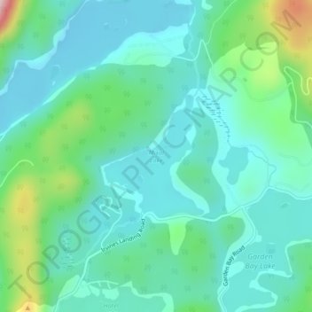
Name: Mixal Lake topographic map, elevation, terrain.
Average elevation: 75 m
Minimum elevation: 1 m
Maximum elevation: 349 m
Other topographic maps
Click on a map to view its topography, its elevation and its terrain.
Pender Harbour
Canada > British Columbia > Area A (Egmont/Pender Harbour) > Madeira Park
Pender Harbour, Madeira Park, Area A (Egmont/Pender Harbour), Sunshine Coast Regional District, British Columbia, V0N 2H0, Canada
Average elevation: 110 m
Egmont
Canada > British Columbia > Area A (Egmont/Pender Harbour) > Egmont
Egmont, Area A (Egmont/Pender Harbour), Sunshine Coast Regional District, British Columbia, V0N 1N0, Canada
Average elevation: 111 m