
Minya Governate topographic map
Interactive map
Click on the map to display elevation.
About this map
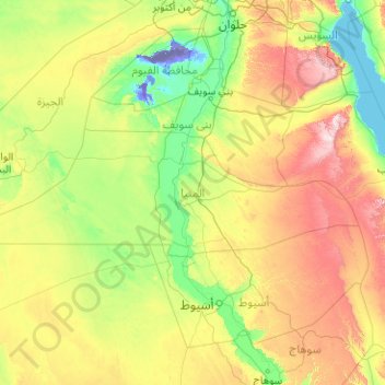
Name: Minya Governate topographic map, elevation, terrain.
Location: Minya Governate, Egypt (27.58536 28.62506 28.80263 32.65393)
Average elevation: 270 m
Minimum elevation: -47 m
Maximum elevation: 1,467 m
Other topographic maps
Click on a map to view its topography, its elevation and its terrain.
Al Shaykh Fadl
Egypt > Minya Governate > Al Shaykh Fadl
Al Shaykh Fadl, Markaz Samalut, Minya Governate, Egypt
Average elevation: 35 m