
Lone Pine topographic map
Interactive map
Click on the map to display elevation.
About this map
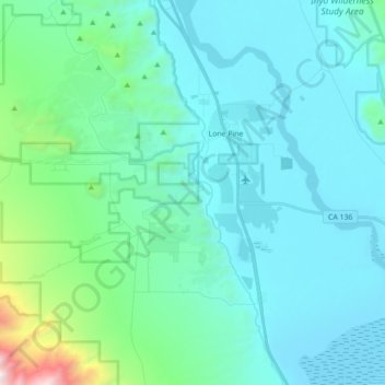
Name: Lone Pine topographic map, elevation, terrain.
Location: Lone Pine, Inyo County, California, 93545, United States (36.51271 -118.11607 36.65366 -118.04095)
Average elevation: 1,298 m
Minimum elevation: 1,084 m
Maximum elevation: 2,953 m
Lone Pine is a census designated place (CDP) in Inyo County, California, United States. Lone Pine is located 16 miles (26 km) south-southeast of Independence, at an elevation of 3,727 feet (1,136 m). The population was 2,035 at the 2010 census, up from 1,655 at the 2000 census. The town is located in the Owens Valley, near the Alabama Hills and Mount Whitney, between the eastern peaks of the Sierra Nevada to the west and the Inyo Mountains to the east. From possible choices of urban, rural, and frontier, the Census Bureau identifies this area as "frontier". The local hospital, Southern Inyo Hospital, offers standby emergency services. The town is named after a solitary pine tree that once existed at the mouth of Lone Pine Canyon. On March 26, 1872, the very large Lone Pine earthquake destroyed most of the town and killed 27 of its 250 to 300 residents.
Other topographic maps
Click on a map to view its topography, its elevation and its terrain.
Devils Golf Course
United States > California > Inyo County
Devils Golf Course, Devil's Golf Course Road, Inyo County, California, United States
Average elevation: -80 m
Furnace Creek
United States > California > Inyo County
Furnace Creek, Inyo County, California, 92328, United States
Average elevation: -27 m
Bishop
United States > California > Inyo County
Bishop, Inyo County, California, United States
Average elevation: 1,265 m
Death Valley Playa
United States > California > Inyo County
Death Valley Playa, Inyo County, California, United States
Average elevation: 881 m
Margaret Lake
United States > California > Inyo County
Margaret Lake, Inyo County, California, United States
Average elevation: 3,467 m
Pearsonville
United States > California > Inyo County
Pearsonville, Inyo County, California, United States
Average elevation: 796 m
Cirque Peak
United States > California > Inyo County
Cirque Peak, Inyo County, California, United States
Average elevation: 3,600 m
Mount Whitney
United States > California > Inyo County
Mount Whitney, Inyo County, CAL Fire Southern Region, California, United States
Average elevation: 3,903 m
Badwater
United States > California > Inyo County
Badwater, Inyo County, California, United States
Average elevation: 161 m