
Denbigh topographic map
Interactive map
Click on the map to display elevation.
About this map
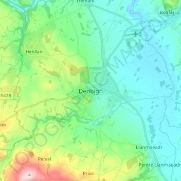
Name: Denbigh topographic map, elevation, terrain.
Location: Denbigh, Denbighshire, Wales, LL16 3UN, United Kingdom (53.14538 -3.45783 53.22538 -3.37783)
Average elevation: 102 m
Minimum elevation: 21 m
Maximum elevation: 374 m
Other topographic maps
Click on a map to view its topography, its elevation and its terrain.
Ruthin
United Kingdom > Wales > Denbighshire
Ruthin, Denbighshire, Wales, LL15 1BU, United Kingdom
Average elevation: 162 m
Tremeirchion
United Kingdom > Wales > Denbighshire
Tremeirchion, Denbighshire, Wales, United Kingdom
Average elevation: 123 m
Llangollen
United Kingdom > Wales > Denbighshire
Llangollen, Denbighshire, Wales, LL20 8PS, United Kingdom
Average elevation: 279 m