
Concord topographic map
Interactive map
Click on the map to display elevation.
About this map
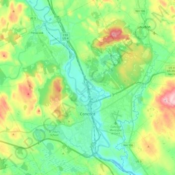
Name: Concord topographic map, elevation, terrain.
Location: Concord, Merrimack County, New Hampshire, United States (43.15179 -71.66871 43.30982 -71.45677)
Average elevation: 131 m
Minimum elevation: 55 m
Maximum elevation: 304 m
Other topographic maps
Click on a map to view its topography, its elevation and its terrain.
New London
United States > New Hampshire > Merrimack County
New London, Merrimack County, New Hampshire, 03257, United States
Average elevation: 365 m
Hooksett
United States > New Hampshire > Merrimack County
Hooksett, Merrimack County, New Hampshire, 03106, United States
Average elevation: 130 m
Sutton
United States > New Hampshire > Merrimack County
Sutton, Merrimack County, New Hampshire, United States
Average elevation: 327 m