
Fairview Mountain topographic map
Interactive map
Click on the map to display elevation.
About this map
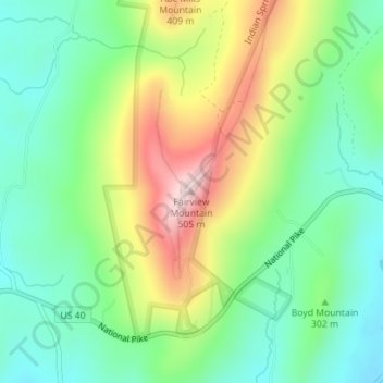
Name: Fairview Mountain topographic map, elevation, terrain.
Location: Fairview Mountain, Washington County, Maryland, 21711, USA (39.65588 -77.96922 39.65598 -77.96912)
Average elevation: 294 m
Minimum elevation: 179 m
Maximum elevation: 497 m
Other topographic maps
Click on a map to view its topography, its elevation and its terrain.
Bush River
Bush River, Bush River Road, Edgewood, Harford County, Maryland, 21010, USA
Average elevation: 8 m
White Marsh
USA > Maryland > White Marsh
White Marsh, Baltimore County, Maryland, 21128, USA
Average elevation: 36 m
Grahams Green Acres
USA > Maryland > Grahams Green Acres
Grahams Green Acres, Carroll County, Maryland, 21776, USA
Average elevation: 223 m
South River
USA > Maryland > Withernsea
South River, Rolling Road, Annapolis Landing, Withernsea, Anne Arundel County, Maryland, 21037, USA
Average elevation: 10 m
Sugarloaf Mountain
Sugarloaf Mountain, Frederick County, Maryland, 20842, USA
Average elevation: 200 m