
Williamsport topographic map
Interactive map
Click on the map to display elevation.
About this map
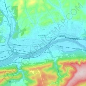
Name: Williamsport topographic map, elevation, terrain.
Location: Williamsport, Lycoming County, Pennsylvania, United States (41.21872 -77.09593 41.26456 -76.98168)
Average elevation: 253 m
Minimum elevation: 149 m
Maximum elevation: 615 m
Other topographic maps
Click on a map to view its topography, its elevation and its terrain.
Lycoming Township
United States > Pennsylvania > Lycoming County
Lycoming Township, Lycoming County, Pennsylvania, United States
Average elevation: 284 m
Grimesville
United States > Pennsylvania > Lycoming County > Old Lycoming Township
Grimesville, Old Lycoming Township, Lycoming County, Pennsylvania, 17702, United States
Average elevation: 203 m
Beaver Lake
United States > Pennsylvania > Lycoming County
Beaver Lake, Lycoming County, Pennsylvania, 17758, United States
Average elevation: 341 m