
Hood River topographic map
Interactive map
Click on the map to display elevation.
About this map
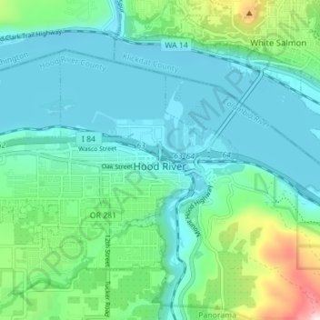
Name: Hood River topographic map, elevation, terrain.
Location: Hood River, Hood River County, Oregon, United States (45.69298 -121.56508 45.72651 -121.49538)
Average elevation: 112 m
Minimum elevation: 14 m
Maximum elevation: 504 m
Temperatures for the year as a whole are slightly cooler than in most other low-elevation towns in the region, especially at night because of air drainage off the surrounding mountains.
Other topographic maps
Click on a map to view its topography, its elevation and its terrain.
Odell
United States > Oregon > Hood River County
Odell, Hood River County, Oregon, United States
Average elevation: 244 m
Parkdale
United States > Oregon > Hood River County > Parkdale
Parkdale, Hood River County, Oregon, United States
Average elevation: 538 m
Badger Lake Dam
United States > Oregon > Hood River County
Badger Lake Dam, Hood River County, Oregon, United States
Average elevation: 1,565 m
Government Cove
United States > Oregon > Hood River County > Cascade Locks
Government Cove, Cascade Locks, Hood River County, Oregon, United States
Average elevation: 89 m
Cascade Locks Marine Park
United States > Oregon > Hood River County > Cascade Locks
Cascade Locks Marine Park, Cascade Locks, Hood River County, Oregon, United States
Average elevation: 72 m
Mount Hood
United States > Oregon > Hood River County
Mount Hood, Hood River County, Oregon, United States
Average elevation: 2,716 m
Dee
United States > Oregon > Hood River County
Dee, Hood River County, Oregon, United States
Average elevation: 424 m
Columbia River
United States > Oregon > Hood River County > Cascade Locks
Columbia River, Cascade Locks, Hood River County, Oregon, United States
Average elevation: 543 m
Cascade Locks
United States > Oregon > Hood River County
Cascade Locks, Hood River County, Oregon, United States
Average elevation: 101 m
Shellrock Spring
United States > Oregon > Hood River County
Shellrock Spring, Forest Road 17, Hood River County, Oregon, United States
Average elevation: 1,157 m