
Saint-Florent-sur-Cher topographic map
Interactive map
Click on the map to display elevation.
About this map
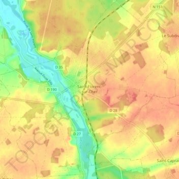
Name: Saint-Florent-sur-Cher topographic map, elevation, terrain.
Average elevation: 149 m
Minimum elevation: 117 m
Maximum elevation: 169 m
Other topographic maps
Click on a map to view its topography, its elevation and its terrain.
Sancerre
France > Centre-Val de Loire > Cher
Sancerre, Bourges, Cher, Centre-Val de Loire, Metropolitan France, 18300, France
Average elevation: 212 m
Chavignol
France > Centre-Val de Loire > Cher > Amigny
Chavignol, Amigny, Sancerre, Bourges, Cher, Centre-Val de Loire, Metropolitan France, 18300, France
Average elevation: 282 m
Raymond
France > Centre-Val de Loire > Cher
Raymond, Saint-Amand-Montrond, Cher, Centre-Val de Loire, Metropolitan France, 18130, France
Average elevation: 187 m