
Portsmouth topographic map
Interactive map
Click on the map to display elevation.
About this map
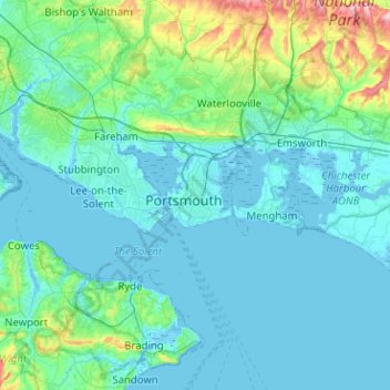
Name: Portsmouth topographic map, elevation, terrain.
Location: Portsmouth, South East, England, PO1 5QH, United Kingdom (50.64368 -1.23561 50.96368 -0.91561)
Average elevation: 28 m
Minimum elevation: -5 m
Maximum elevation: 236 m
Portsmouth is 73.5 miles (118.3 km) by road from central London, 49.5 miles (79.7 km) west of Brighton, and 22.3 miles (35.9 km) east of Southampton. It is located primarily on Portsea Island and is the United Kingdom's only island city, although the city has expanded to the mainland. Gosport is a borough to the west. Portsea Island s separated from the mainland by Portsbridge Creek, which is crossed by three road bridges (the M275 motorway, the A3 road, and the A2030 road), a railway bridge, and two footbridges. Portsea Island, part of the Hampshire Basin, is low-lying; most of the island is less than 3 metres (9.8 ft) above sea level. The island's highest natural elevation is the Kingston Cross road junction, at 21 feet (6.4 m) above ordinary spring tide.
Other topographic maps
Click on a map to view its topography, its elevation and its terrain.
Spider Lake
United Kingdom > England > Portsmouth
Spider Lake, Portsmouth, England, PO16 9NQ, United Kingdom
Average elevation: 1 m