
Dnepr topographic map
Interactive map
Click on the map to display elevation.
About this map
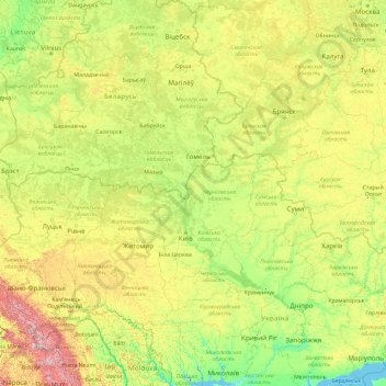
Name: Dnepr topographic map, elevation, terrain.
Location: Dnepr, Ріпкинський район, Oblast' di Černihiv, 74987, Ucraina (46.48514 30.02095 55.87170 35.19711)
Average elevation: 194 m
Minimum elevation: -8 m
Maximum elevation: 1,978 m
Other topographic maps
Click on a map to view its topography, its elevation and its terrain.
Орлівка
Орлівка, Новгород-Сіверська міська громада, Новгород-Сіверський район, Oblast' di Černihiv, 16070, Ucraina
Average elevation: 174 m