
Livonia topographic map
Interactive map
Click on the map to display elevation.
About this map
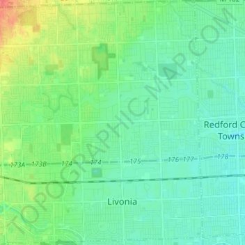
Name: Livonia topographic map, elevation, terrain.
Location: Livonia, Wayne County, Michigan, United States (42.35247 -83.43367 42.44203 -83.31283)
Average elevation: 201 m
Minimum elevation: 188 m
Maximum elevation: 238 m
Other topographic maps
Click on a map to view its topography, its elevation and its terrain.
Northville
United States > Michigan > Wayne County
Northville, Wayne County, Michigan, United States
Average elevation: 258 m
Brownstown Charter Township
United States > Michigan > Wayne County
Brownstown Charter Township, Wayne County, Michigan, 48134, United States
Average elevation: 183 m
Northville Township
United States > Michigan > Wayne County
Northville Township, Wayne County, Michigan, United States
Average elevation: 260 m
Detroit
United States > Michigan > Wayne County
Detroit, Wayne County, Michigan, United States
Average elevation: 187 m
Grosse Ile Township
United States > Michigan > Wayne County
Grosse Ile Township, Wayne County, Michigan, 48138, United States
Average elevation: 179 m
Canton
United States > Michigan > Wayne County > Canton
Canton, Wayne County, Michigan, United States
Average elevation: 214 m
Lincoln Park
United States > Michigan > Wayne County > Lincoln Park
Lincoln Park, Wayne County, Michigan, 48146, United States
Average elevation: 180 m
Belle Isle
United States > Michigan > Wayne County > Detroit
Belle Isle, Detroit, Wayne County, Michigan, 48207, United States
Average elevation: 177 m
Plymouth
United States > Michigan > Wayne County
Plymouth, Wayne County, Michigan, United States
Average elevation: 223 m
Rockwood
United States > Michigan > Wayne County
Rockwood, Wayne County, Michigan, United States
Average elevation: 178 m